Automating your Geographical Data with Mapsemble API.
TL;DR: Check out the video below for a recap.
The Mapsemble API is another way to upload your geographical data, alongside XLS/CSV files, GeoJSON, or drawing directly on the map. By using the API, you can ensure that your data stays updated automatically, streamlining the process of managing large-scale geographical datasets.
Why Post Your Data to Mapsemble?
Some mapping solutions, like the Google Maps JavaScript API, allow you to render data directly from your browser without storing it on their servers. Google simply displays the data you provide but does not host it.
So why does Mapsemble need your data?
Mapsemble supports advanced features that require hosting your data on our servers:
- Pagination and filtering: Upload thousands of features and navigate them efficiently with pagination, ensuring only relevant data loads on each page. We’re also working on custom filters to refine displayed map data dynamically.
- Spatial Queries: Mapsemble loads only the features visible in your current viewport. As you zoom in or pan around, results update dynamically—similar to platforms like Airbnb. This requires spatial queries, which can only function if the geometry is stored on our servers.
- Performance Optimization: Hosting your data allows us to optimize how it loads, ensuring smooth performance. That’s why maps with 100,000+ features can load in a snap.
How the API works
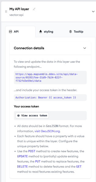
When you add an API layer to your map, an endpoint is automatically generated for posting your data. Instructions for authentication and usage appear directly in the layer, eliminating the need to consult external documentation.
Your API endpoint will follow this format:
https://app.mapsemble.com/api/data-source/{dataSource}/data

The data you post should be in the GeoJSON format.
{
    "type": "FeatureCollection",
    "name": "Itinerarios de la isla de Tenerife",
    "features": [
    {
        "type": "Feature",
        "id": "**UNIQUEID**"
        "geometry": {
            "type": "Point",
            "coordinates": [125.6, 10.1]
        },
        "properties": {
            "itinerario_matricula": "PNT-31.2",
            "itinerario_nombre": "Ramal Degollada del Sombrero de Chasna",
          }
        }
    ]
}
The Mapsemble API follows standard REST principles:
- GET – Retrieve all GeoJSON features in a layer.
- POST – Add new features (maximum 1,000 per request).
- PATCH – Update specific elements of a feature without modifying the rest.
- PUT – Create or replace existing features.
- DELETE – Remove specific features.
Unique ID per feature
To ensure data consistency and avoid duplicates, each feature must have a unique ID. By default, this is the id key within the feature. Alternatively, you can designate a property in the properties section as a unique identifier.

Embedding and enhanced security
You can embed your map anywhere using the snippet provided in the Embed section—no need to whitelist domains or manage access keys.
For added security, enable Enhanced Security Mode. This requires an access token (JWT) each time your map is viewed. These tokens are single-use and valid for a limited time, ensuring secure access control.
Recap
Want a quick overview? Watch my video tutorial explaining the API in action:
Mapsemble’s API makes it possible to build maps and navigate large scale geographical data with ease.
What to know more? drop me a line or leave a comment.